The United States Geological Survey (USGS) provides a website titled “METHODS FOR DETERMINING STREAMFLOW REQUIREMENTS FOR HABITAT PROTECTION” (link USGS Wetted-Perimeter Method) that contains a clear and succinct explanation of their wetted-perimeter habitat evaluation method. Please take a couple of minutes and review this site. The following text is excerpted from this USGS web-site:
“The Wetted-Perimeter method assumes that there is a direct relation between the wetted perimeter in a riffle and fish habitat in streams (Annear and Conder, 1984; Lohr, 1993). The wetted perimeter of a stream, defined as the width of the streambed and stream banks in contact with water for an individual cross section, is used as a measure of the availability of aquatic habitat over a range of discharges (Annear and Conder, 1984; Nelson, 1984). The Wetted-Perimeter method is based on a plot of the relation between wetted perimeter and discharge (fig. 2). The point of maximum curvature in this relation is used to determine the streamflow required for habitat protection (emphasis added).”
The FERC recognizes the USGS Wetted Perimeter analysis as a “standard setting method”. Wetted perimeter and wetted area are mathematically linked. A wetted area analysis is fundamentally the same as the USGS Wetted Perimeter analysis with regard to determining minimum flow that is protective of aquatic habitat.
A wetted area analysis simultaneously addresses project impacts on all river cross sections. Similar to the Wetted Perimeter method, maximum curvature in a plot of wetted reach area versus flow shows the point at which river bottom is being exposed at the highest rate. This flow is the threshold minimum for habitat protection for the same reason stated per the Wetted-Perimeter method.
Districts endorse a wetted area analysis of project impacts; however, they are inconsistent within their documents regarding interpretation of threshold minimum area (and thus flow) for habitat protection.
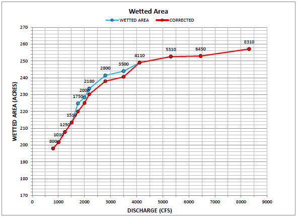
The figure below was excerpted from Districts’ Draft License Application submitted to FERC. It is apparent from the corrected and uncorrected results that minimum protective flow (point of maximum curvature) occurs between 2,800 cfs (at the absolute minimum) and 4,110 cfs.
Districts endorse that inflection point at which area becomes relative insensitive to flow (and thus protective of habitat per the wetted area/perimeter method) occurs at around 4,100 cfs. Districts state on page 144 of their Draft License Application submitted to FERC:
“Total wetted acres increase systematically with discharge; however, the relationship is not linear. The most significant changes in wetted area occur for discharges below about 4,000 cfs, reflecting the filling of the main channel and activation of larger side channels. The range from 800 cfs to 4,110 cfs adds 51 acres of aquatic habitat.”…“The range from 4,110 cfs to 8,310 cfs adds only 8 acres of additional aquatic habitat.”