The form to sign the petition is located at the bottom of this page.
Despite growing opposition, Idaho Irrigation District and New Sweden Irrigation District (Districts) are pursuing their County Line Hydroelectric Projects (CLHP). The Osgood Reach refers to the 3.5-mile portion of the Snake River that will be affected by the CLHP.
A dam exists on the Snake River north of County Line Road to divert water into Districts’ canals on both sides of the river. Districts want to install hydroelectric turbines next to their canals about 3.5 miles downstream of the dam with turbine discharge routed back to the Snake River. Please review the following pages on this web site regarding the CLHP:
- CLHP description – link County Line Hydroelectric Project (CLHP)
- Studies to assess CLHP impacts on river habitat – link CLHP Impacts
The Districts must secure a license from the Federal Energy Regulatory Commission (FERC) and water rights from Idaho Department of Water Resources.
Districts filed their Draft License Application (DLA) to the FERC on September 30, 2018 in which they request a FERC license that will allow them to divert up to 2,000 cfs (cubic feet per second) Snake River flow to feed their hydroelectric plants as long as remaining river flow does not drop below 1,000 cfs (called “minimum bypass flow” or MBF) . Historically, 1,000 cfs flow has occurred less than 1 percent of the time. Districts submitted a Final License Application to FERC on December 18, 2019 and a Revised License Application on September 29, 2020.
The FERC issued a Final Environmental Assessment (FEA) on February 10, 2023 with project license articles based on a FERC Staff Alternative. The FERC typically issues a project license shortly after issue of a FEA. License articles allow the Districts to divert water around the Osgood Reach for power generation as long as flow within the Osgood Reach does not fall below:
- 3,500 cfs from May through August
- 2,500 cfs during September and October, and
- 1,500 cfs from November through April.
The US Department of Interior, Idaho Department of Fish and Game, various other state and federal agencies and other stakeholders submitted reasoned comments supported by empirical data that FERC’s license flows will not protect the fishery, wildlife within the river, recreation or public interests. The FERC rejected all these comments and issued the FEA with the same flows as the draft EA. You are encouraged to go onto FERC’s eLibrary website (https://elibrary.ferc.gov/eLibrary/search), type in docket P-14513 and download the FEA (item number 20230210-3030 dated February 10, 2023). You can make your own assessment regarding the integrity of FERC’s logic rejecting stakeholder comments (FEA Appendix H).
The Districts recreation study identified a minimum flow of 3,500 cfs necessary for novice boaters to traverse the reach and a minimum flow of 2,800 cfs for knowledgeable recreational boaters to safely traverse the reach without dragging across shoals or hitting submerged rocks. FERC selected 3,500 cfs from May through August to preserve recreational boating. Osgood Reach flow is typically higher than 3,500 cfs during May through August and Districts’ canal capacity is mostly used for irrigation purposes, thus Districts need for additional diversion for power generation is low.
Osgood Reach flow declines during the fall. FERC selected 2,500 cfs during September and October as a compromise to allow some recreational use of the reach while Districts divert water to their power plants. A 2,500 cfs flow through the Osgood Reach:
- Is the absolute minimum flow mentioned by any Stakeholder for power boating. Power boating would be reserved for only the most risk seeking boater and persons willing to occasionally drag their boats over gravel bars.
- Would reduce recreational access during prime brown trout fishing during the fall
- Will reduce brown trout spawning habit by about 20%.
- Will impair the ability of some residents living along the Osgood Reach to exercise their existing water rights to irrigate their yards with water from the Snake River.
FERC will require Districts to install a new gravel boat launch ramp immediately downstream of the County Line Road bridge. Drift boats currently cannot use the Osgood Reach because Districts’ dam blocks all boat access from upstream. This ramp will provide drift boat access to part of the reach. The new launch ramp will not materially mitigate adverse impacts on power boating because if Osgood Reach flow is high enough to use the new ramp, it is also high enough for boats to traverse the reach from the existing West River Boat ramp located farther downstream.
Directives of the existing IDFG fishery management plan are to improve sport fishing opportunities, improve angler boat access and maintain the trophy component to the trout fishery. Proposed license flow per the FERC Staff Alternative are incompatible with these directives.
Stakeholders believe a 1,500 cfs minimum Osgood Reach flow from November through April is problematic because:
- It will result in the death of trout year after year (Idaho Department of Fish and Game estimates a 40% to 50% reduction in brown trout population)
- It severely limits access to BLM lands for hunting
- Will essentially prohibit boating recreation through the reach during the spring (March and April)
- It essentially precludes residents from irrigating their yards during April
FERC based their assessment of flow impacts on overwinter winter trout survival entirely on habitat suitability modeling. FERC used winter habitat models as a proxy for overwinter trout survival even though Districts’ and FERC staff said this should not be done. The model combines habitat suitability criteria or “HSC” (such as probability of finding trout at a given velocity or depth) with river physical properties (such as velocity and depth as a function of river flow) to estimate acres of suitable habitat as a function of flow. Districts admit that no winter HSC curves for trout exists in literature and collected no reach specific HSC data during icing conditions. Fishery professionals disagreed on even the most basic model inputs and which velocity should be used with HSC. Districts state that they cannot rigorously model ice formation that is required to determine winter physical properties. Districts instead provided “opinions” of ice formation to support winter reach physical properties.
The Idaho Department of Fish and Game (IDFG) annually counts the number of young trout in the South Fork. The figure below shows this IDFG data graphed against previous winter flow. Each black circle in the graph reflects one year of IDFG data. The term “recruitment” refers to juvenile trout that survive the winter and are recruited into the overall population. IDFG empirical data for the South Fork is applicable to the Osgood reach because the South Fork is essentially the same river, is of similar size and is located in a the same geographic and climatic region. The graph of empirical data becomes asymptotic above 3000 cfs meaning that bypass flows below 3000 cfs would not protect the juvenile trout fishery. Protective flow per IDFG empirical data of around 3,000 cfs is confirmed by results of two other “standard setting methods” recognized by the FERC (Tennant method and wetted perimeter/area).
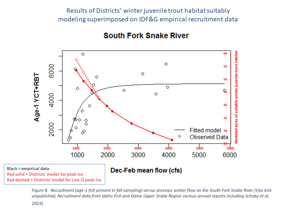
Districts issued a “Fishery Investigation (Study 1)” to the FERC in 2017 in which they cited numerous literature references based on empirical data (that is, actual measured data) that conclude a positive correlation exists between increased winter or spring flow and trout overwinter survival. Districts stated that they could not find single reference world-wide that supports their assertion that lowering winter flow would enhance overwinter survival of trout.
The figure above shows results of Districts’ winter juvenile trout habitat suitability model results in red color. Winter trout habitat suitability model results presented by FERC in the DEA are very similar and show the same direction trends. A computer simulation is validated by whether it can replicate empirical (measured) data. Competent empirical data is never rejected in lieu of computer simulation results when conflicting; simulation results are rejected in lieu of empirical data. The FERC, however, did the exact opposite. The DEA omits empirical data provided to the FERC in 2017. Directional trends as a function of flow from the Districts’ winter juvenile model are opposite of empirical data. Districts’ winter juvenile model is either invalid or its results are such an extremely poor indicator of impact of flow on overwinter juvenile trout survival that it is useless for this purpose.
The juvenile trout modeling results are useless for FERC licensing purposes for reasons stated above. There is strong reason to suspect all winter model results presented in the DEA are equally useless because winter modeling methodology for adult trout is the same as for juvenile trout.
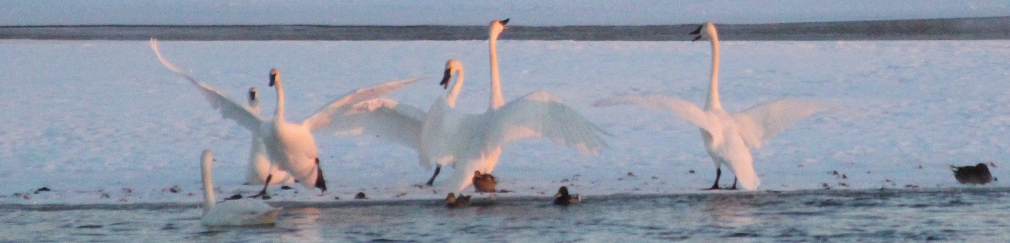
Large numbers of waterfowl, including trumpeter swans, enter the reach during the evening and leave in the morning during late fall and winter. Waterfowl viewing is superb in the reach during the winter because open water exists when most other nearby portions of the Snake River are frozen over.
Districts did not follow their waterfowl study plan was not followed and sampled populations when waterfowl were known to be absent from the reach (that is, they sampled only from 10 AM to 3 PM when waterfowl are typically present from dusk to dawn) which caused these waterfowl to not be counted. The DEA focuses on impacts of ice cover on waterfowl habitat. The DEA concludes that compared to current flow (2,800 cfs mean flow from October through March) a 1,500 cfs license flow will preserve some open water through most of the residential area north of the County Line Road bridge. This is more of a guess than a conclusion because the DEA assessment is based on estimates of ice cover as a function of reach flow developed by the Districts. Districts state they it is impossible rigorously model ice cover as a function of flow so their ice cover estimates are based on the “opinion” of their ice formation consultant. Maps of ice cover contained in the DEA show open water at low flows where residents annual observe ice islands forming at even higher flows.
Summary
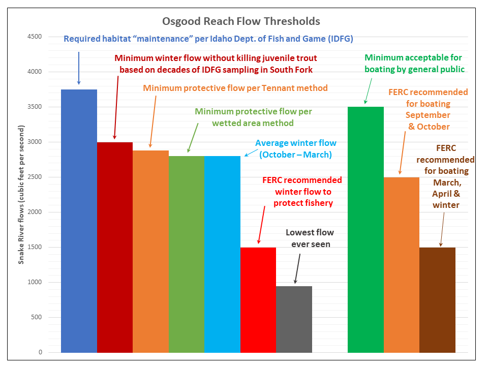
The following graph shows the Districts’ requested 1,000 cfs licensed minimum flow in context of other flow thresholds pertinent to the Osgood Reach:
- 3,750 cfs – Published Idaho Department of Fish and Game (IDFG) minimum flow required to maintain long term health of Snake River habitat near Idaho Falls.
- 3,500 cfs – Determined by Districts as the minimum flow considered “acceptable” for boat navigation by the general public without expert river knowledge
- 3,000 cfs – Flow below which overwinter survival of juvenile trout declines based on decades of IDFG population sampling in the South Fork
- 2,880 cfs – Minimum flow necessary to avoid river habitat damage per the Tennant method, which FERC recognizes as a “standard setting method” (link to Tennant Method page in this website). Tennant method has been used for decades and prescribes minimum flow limits to protect habitat based on field observation
- 2,800 cfs – Minimum flow necessary to avoid river habitat damage per a wetted area analysis (link to USGS Wetted-Perimeter Method page in this website). Wetted-perimeter/area method is based on the common sense and statistically supported concept that river habitat will be damaged if the river is drained past the point where bottom is quickly being exposed
- 2,800 cfs – Average winter Osgood Reach flow (October – March) based on historical USGS flow statistics
- 2,000 cfs – Minimum reach flow that Districts state must be licensed for both of their hydroelectric projects to be economically viable
- 1,500 cfs – FERC proposed licensed minimum reach flow from November through April
- 950 cfs – Historical lowest flow ever recorded within the Osgood Reach (occurs on average only 3 days per year)
FERC proposed licensed minimum flows through the Osgood Reach are based on winter habitat preference computer model to justify claims that 1,500 cfs flow will “enhance” the fishery. Winter trout habitat models compound speculation on habitat suitability criteria with speculation on winter river physical properties. The juvenile trout modeling results are useless for FERC licensing purposes for reasons stated above. There is strong reason to suspect Districts’ winter model results for adult trout is equally useless because Districts winter modeling methodology for adult trout is the same as for juvenile trout.
Waterfowl view is spectacular in the project reach during fall and winter. Implementation of the CLHP will drive waterfowl away due to increased icing at FERC proposed 1,500 cfs minimum bypass flow.
The Districts diversion dam is unique in that it is the only canal intake diversion structure on the Snake River and South Fork between Idaho Falls and Palisades Dam that spans the entire width of the river. Districts’ diversion dam already profoundly impacts recreation within the project reach by blocking all boat access to the reach from upstream. It prohibits the majority of the public from using drift boats within the reach because drift boats must drift into the reach from upstream. Districts’ diversion dam has impacted the project reach fishery by isolating the reach from upstream habitat. Fish could migrate to and from the reach all the way to Palisades Dam or up the Henry’s Fork if not for the Districts’ diversion dam. Trout sampling completed by the Idaho Department of Fish and Game show dramatically lower trout density below the dam compared to above. The dam has limited public access to cutthroat trout that may not spawn within the reach, but could migrate into the reach if not for the diversion dam.
The Districts have already usurped much public use of the reach and now propose to shift the balance of reach use further in their favor at the expense of the public.
Districts proposed to market power from their hydro plants subject to the 1978 Public Utility Regulatory Policies Act. The Idaho Public Utilities Commission determined in 2015 that: “It is uncontested that utilities do not need additional generating capacity and that PURPA and non-PURPA generation exceeds Idaho Power’s and Rocky Mountain’s minimum average loads.” Eastern Idaho doesn’t need power from the CLHP.
The Osgood Reach contains the last stretch of natural flowing river for over 40 miles from north of Roberts to Firth. We believe that de-watering of the Osgood Reach as proposed by the Districts would:
- Exacerbate ice formation and low water temperatures with adverse impact on the fishery
- Expose large areas of the river bottom to freezing with adverse impact on the food chain and cascading adverse impacts on the fishery and waterfowl throughout the year
- Adversely impact winter habitat of waterfowl that congregate in the open water downstream of the diversion dam
- Reduce water depth thereby restricting or eliminating river access via watercraft for recreation during prime autumn brown trout fishing and waterfowl hunting season
- Adversely impact scenic quality.
We are not opposed to energy development. We are against destruction of wildlife habitat, impairment of scenic quality, degradation of native trout habitat, and loss of recreational use when benefits consist of marginal economic gains to a small select group. If you agree, please sign our petition requesting that federal, state and county regulatory agencies deny authorizations for the County Line Hydroelectric Project.
To the best of our knowledge, nobody has access to our signature information but us. We will not use signature information for any purpose other than this petition.
Our petition software allows one signature per e-mail address. Once you sign, you will receive an e-mail asking you to click on a link to confirm your signature.
We are asking for the minimum information we believe necessary for regulatory agencies to verify that signatures are authentic.
Petition text:
“We the undersigned:
1. Oppose the County Line Hydroelectric Project (FERC Docket P-14513) because we believe it is not in the best interest of the local public;
2. Request that federal, state and county agencies deny authorizations for the County Line Hydroelectric Project.”
While we need clean energy sources, the CLHP is simply not worth the trade off. It would be a shortsighted in the extreme and should not be approved.
Sadly, Idaho has no provision for minimum stream flows and irrigators want to keep it that way. Once they are given a “water right” the water “belongs” to them. Currently, during irrigation season, the river itself has no rights at all to the water it carries.
This hydroelectric project proposal would extend those water rights for this section of the river to include winter and early spring months. There are currently no rights granted that would permit dewatering during this critical time of the year. All the water in the river already “belongs” to irrigators for most of the year. Let’s not extend that ownership to winter flows as well.
While most of the Snake River in this area ices over in the winter, the stretch for several hundred yards below the diversion remains open at all times with water spilling over the entire length of the diversion providing critical oxygenation and open water that congregates fish, waterfowl, game birds raptors and other wildlife during this very difficult time of year. I am lucky enough to observe this stretch of the river from the windows of my home. To drastically reduce flows (and in many years completely dewater the river) as is proposed by this project would have a devastating effect.
I am also concerned about the proposed, increased canal bank heights on both of the involved canals and how that would affect the flood plain between the two canals in extremely high water conditions.
This is a very bad, short sighted and blatantly selfish idea. It marginalizes the interests of wildlife and everyone who lives or recreates on this stretch of the river, focusing only on the benefit for a relative few individuals who would profit financially from it.
In my opinion, the people applying for new water rights for up to every drop in this section of the river during winter and early spring’s low water flows don’t need another government-subsidized source of income at the expense of the river and the wildlife and people who live here.
John, I agree with you. To sacrifice something so great for short term benefit and profit would be a loss. Please help us keep what we love, and don’t ruin one of the most beautiful parts of the valley.
I agree, This is a very bad, short sighted and blatantly selfish idea. It marginalizes the interests of wildlife and everyone who lives or recreates on this stretch of the river, focusing only on the benefit for a relative few individuals who would profit financially from it.
I ask our public officials not to approve this project.
I used to live close to Idaho Falls. This was heartbreaking to learn about. Going to forward this to everyone I know.
How about we give this old river a break? There is not a harder working river in the west. It’s time to let her and the creatures it supports be. Please…???
The restricted winter flow to the affected section of the river, would essentially assure that the river froze solid through the “dewatered” section, thus rendering it sterile of the insect and invertebrate fauna required to maintain fish and avian fauna along that and downstream sections, and potentially causing the extinction of Hexagenia may-flies which are now limited in range to the section of the river below the proposed hydro -development sites, and bringing into play Potential “Endangered Species” designation with further Federal intervention on flow control, and usage restrictions on that and downstream sections of river. Better to leave the water in the river, and let nature adapt to the coming “global warming” changes without adding to the deleterious effects that reduced winter flows would cause, while certainly impacting fish and avian food stocks for the entire year, in the “essentially de-watered” section of the river.
Doing damage to a river in order to produce a few kilowatts is always a bad idea. There are many other power sources to supply our community’s needs other than raping a public resource for private benefit.
As a home owner along the canal…I see no benefit to the prosaic. I am also concerned about potential flooding along the canals.
The proposed county line hydroelectric project is a bad idea with dire consequences. The proposal requires approximately 66% of the typical winter flows in that stretch of the Snake River. This stretch currently has open water all winter which is critical for waterfowl, mammals, fish and aquatic invertebrates that utilize the river and adjacent riparian zone. The propsed minimum flow of 1,000 cfs would result in a frozen river and dried up channels with extensive loss of indigenous flora and fauna. A surplus of electriciy is already being produced in eastern Idaho from wind mills , existing hydroprojects etc. which must be exported to other states. Please stand up for the Snake River flows which provide beauty and sustenance to the people and wild life that depend on this water. Please thwart this greedy water grab!
I am greatly concerned about the fish and wildlife impact this diversion will have. Fishing and boating is an important part of this section of the river. The people living on and near the river will see no benefit from this project.
However, it will effect their property value and may require flood insurance where it is not required now. My guess is that a majority of the power produce will be sold out of state.
No no no
This will not benefit anyone local and any money derived from this will only go to enrich those stealing from Idaho and our property owners who love the views, the wildlife and the wonderful ambience of living in this area. The shameful effect of this proposed project would be the same as any strip mining done elsewhere in Idaho and the harmful after effects would be a bitter taste for decades to come.
Diverting water from the river to be able to sell it out of State is pure greed. It will forever effect the 3 mile stretch of river. The wild life fishing and boating this river is famous for.
We all want clean energy but this is way too expensive in terms of environment degradation. I own land at the diversion and oppose this project. What will happen to all the swans, geese, ducks, river mammals, and countless other wildlife that frequent the river and banks of this habitat rich area? This project is not in the best interest of the people of Idaho.
Not in the best interest of the people of Idaho
No the world is already polluted. No more factory’s. Figure out a clean way to produce stuff.
Fish and game concerns affects us all, but putting us all in a flood zone by raising the canals, and depleting our beautiful river will drop property values accordingly. I greatly oppose this for myself and my fantastic neighbors.
As I read through the comments, I noticed some common themes concerning harm to fish and wildlife, damage to the river, impacts to boating and recreation, environmental degradation and greed. If I was a canal company board member, I don’t think I would want my neighbors to view my “green energy project” in those terms. As a nation, I think we are finally seeing the value of green energy but is the CLHP the right project for Idaho Falls? It used to be that green energy was synonymous with environmentalism and protection of the environment it appears that the CLHP may be falling short of being truly green. I think most will agree that the comments here paint a picture of a project that runs counter to community values.
So, here are a few specific reasons why I DO NOT SUPPORT the CLHP. 1000cfs! Really? That sounds just plain crazy. Even crazier is thinking that lower water levels are better for fish!?!? I suspect that lower levels in the river means the river will freeze and at greater depth thereby harming the fish, the organisms they feed on, and the vegetation in the river and at the bank level. With a more frozen river and now flowing canals (or frozen canals) how does that affect the birds, deer and other wildlife that depend on the river for life, especially a partially flowing river in the winter? Where is the comprehensive environmental study for this project? As a community you may want to know because the effects of the project are greater than the 3.5 miles that are advertised as being affected. For instance. I’m an avid fisher and I know that water temperatures affect trout feeding and trout spawning. Taking the amount of water they want from the river and reintroducing is downstream will adversely affect water temperature in a much greater area of the river. How will this affect waterfowl hunters in the fall? Will there be adequate water to safely navigate their boats to their favored hunting areas? Is one or two windmills worth of power worth it?
What about running canals all year long? I’ve never seen water running in our canals in the winter. I hear it’s been done but nobody I spoke with has ever seen it. So, if it’s not routinely done is it safe to do so? Will they hold up to the load and the freezing? What about a winter river that is running at about a 1/3 of normal what happens to the water there and is it safe? What happens when water from the canals’ powerplants meets the frozen river? Flooding is bad but what happens when it happens in the winter are we as a community ready for that emergency? And I say community because it will affect more than we know. Do the canal companies have a plan for such a contingency? Are these issues the responsibility of a “Canal Companies” or the local government? If the latter who is going to pay for it? So, I ask again, is this worth one or two windmills worth of power?
So, here are my last questions. Do you feel confident that a canal company can safely operate a power generation plant? As canal operators do they have the expertise to design, operate, and maintain these plants? Can they monitor the water levels in real time and offer transparency to the community to make sure they are only taking what they say they will? Can they react in times of emergency to manage the flow of water safely? Are their canals safe to operate in the winter? What about the diversion dam, how is it affected? Have they told the community and their patrons everything about the project? What modifications will be required to the canals and bridges to support the project? Who will pay for those modifications? What else don’t we know? And, again, is it all worth a little bit of overpriced power that will not directly benefit our community but will undoubtedly harm it?
My wife and I want to go on record that we do not want the license for the County Line Hydroelectric Project to be granted.
Regarding the water flow, the averages for last winter (October – March) were roughly 3600 cfs. The river at my location (the diversion dam) NEVER went below 2500 cfs. To drop flow levels to 1000 cfs would be too low for wildlife and fish. https://www.usbr.gov/pn/hydromet/wygraph.html?list=sifi%20q&daily=sifi%20qd
In our opinion and research, not only the lack of adequate water for the fish at 1000 cfs, but those fish also provide food year-round for the Cormorants, Ospreys, and Eagles. Let alone the habitat for nesting ducks, geese, beaver etc. The Osprey nest literally on the canal inlet and is used year-round by Osprey in the Spring/Summer and Bald Eagles in the Winter. We see them both dive for fish frequently.
If the river is dropped that low, fishing from boats will be impossible (we get many from Idaho Falls from early thaw to October/November).
Building a building also means security lights and cameras. My wife and I don’t want that kind of intrusion reflecting all night off the river. Let alone the total eyesore and blocking the best part of the view we have off our back patio. (The reason we bought this property)
I believe this project needs a full-on Environmental Impact Statement considering the animal and plant life. At the very least we ask that you use the Idaho Fish and Game data for your decision making.