The Idaho Department of Fish and Game (IDFG) “Fisheries Management Plan 2013-2018” states the following “Management Direction” for the portion of the Snake River including the Osgood Reach (portion of the river impacted by the County Line Hydroelectric Project”:
- Maintain conservative cutthrout trout limit
- Improve angler boat access
- Manage for catch rates of 0.5 fish/hour for all trout
- Implement experimental supplemental stocking of fingerling trout
- Maintain trophy component of the trout fishery.
The second and fifth bullet item above will be adversely impacted by implementation of the CLHP, thus implementation of the CLHP is incompatible with IDFG management direction.
The Districts developed the following via their recreation impact study:
- Exceedance flow data based on historical reach flow per USGS data
- Exceedance flow data after implementation of the CLHP
- 3,500 cfs is required for novice boaters to traverse the reach
- 2,800 cfs is the minimum flow necessary to traverse the reach as reported by boaters with strong knowledge of the reach (recreation study set this minimum flow as range of 2,500 cfs to 3,000 cfs)
- 2,200 cfs stated by Districts’ as acceptable for recreation based on opinion of consultants and a redefining the term “acceptable” from the definition stated in the recreational study.
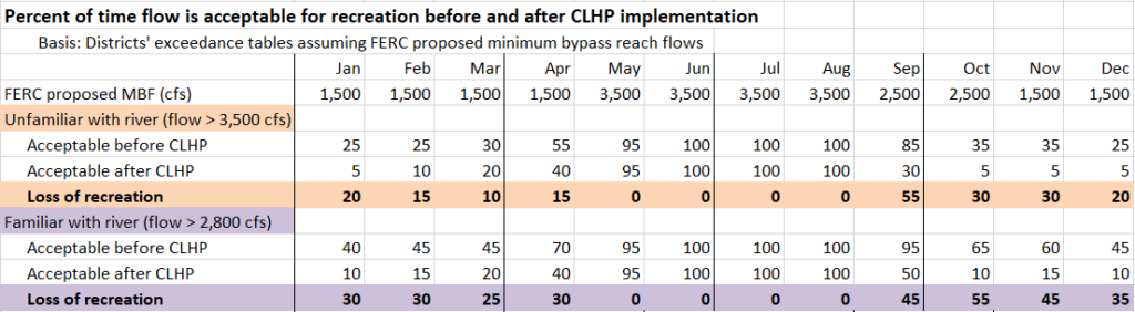
The FERC issued a Draft Environmental Assessment (DEA) on September 7, 2022 in which they propose to license the project allowing the Osgood Reach to be drained down to the following minimum flows or MBF (minimum bypass flow):
- 3,500 cfs MBF from May through August,
- 2,500 cfs MBF during September and October, and
- 1,500 cfs MBF from November through April.
The FERC states in their Draft Environmental Assessment (DEA) thatThe last bullet item above confirms the experience of boaters that use the reach the most; which is, it is unsafe to traverse the reach at flows below 2,800 cfs.
The following table was developed based on FERC proposed monthly MBFs per the DEA, 3,500 cfs and 2,800 cfs acceptable boating flows as described above and 50% (or average) exceedance flow data for the Osgood Reach provided by the Districts. A full probabilistic analysis yields similar results. The table shows that FERC proposed MBFs will protect boating recreation only from May through August. FERC proposed license MBFs will have a large impact on boating during prime brown trout fishing during September and October. FERC proposed MBFs will also adversely impact opportunities for experienced boaters to use the reach during spring months of March and April.
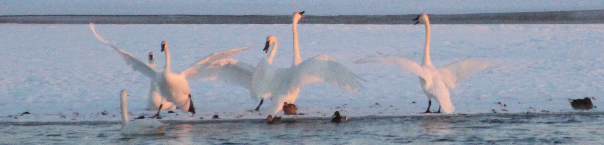
Large numbers of waterfowl congregate in open water within the reach during fall and winter. Districts offered “opinions” on ice formation that show CLHP implementation will cause earlier and more extensive ice formation with the result being to drive waterfowl out of the reach. Districts failed to analyze impact on waterfowl due to lower water in the reach due to the CLHP even though they state that this issue has been “extensively” studied with much information in professional literature. Districts did not follow their study plan and failed to count large numbers of geese and trumpeter swans that enter the reach in the evening and leave in the morning.
FERC’s proposed 1,500 cfs minimum reach flow will not protect waterfowl habitat since incremental ice formation compared to the 2,800 cfs historical mean winter flow will cause waterfowl to leave the reach. CLHP implementation will adversely impact waterfowl viewing during fall and winter, which is a highly valued recreational activity of residents along the river.
CLHP implementation will adversely impact photography of both the river and wildlife using the river, especially waterfowl.